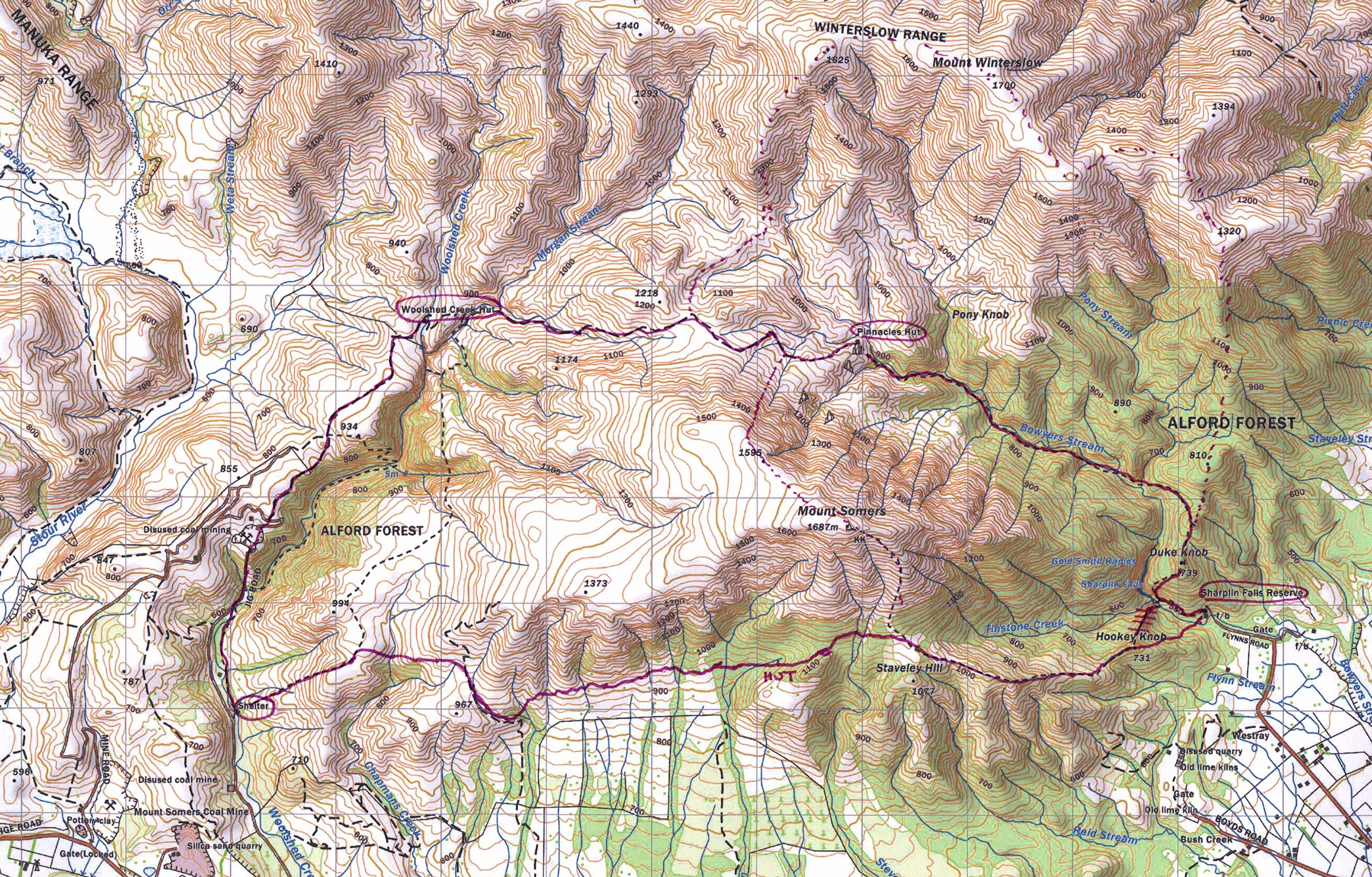
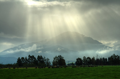
Sunday morning dawned grey and close, only
the foothills visible under a dense blanket of cloud. I had decided that I was going to run
regardless of the weather (but dependant on wind conditions being calm enough
that I not get blown off the mountain).
I had been keen to have a crack at the entire Mt Somers circuit since
the last time I had run at Staverly, but this was to be the first time in a
while that I would be running in grey weather, so I was excited and nervous
about what the day would bring.
I have taken to filling out intentions forms
when I go out into the mountains. The form
I use is online at Adventure Smart is quick and easy to fill out with route and ETA
information, and the website automatically emails copies to your “trusted
contact”, who can monitor your return and duly notify the authorities if you
don’t return when expected. I think that
it is important to be smart when I am venturing into areas where I am vulnerable
to the conditions or the terrain, and the intentions form provides a little
peace of mind to everyone.
The peak of Mt Somers was hidden from view,
but the cloud base seemed reasonably high when I left the car park at the
Sharplin Falls access point of the track, so I figured that I might have some
good views as I ascended. The first part
of the climb (that I had struggled with most recently) seemed infinitely more
runable that it had on the previous occasion.
I attributed this easy-ish start to the cooler weather and the enormous
breakfast I had consumed before setting out.
Before I reached the top of Staverly Hill
the cloud started to close in, the view below growing more indistinct as I
gained height. It wasn’t long before I
was running along the ridgeline, the burnt oranges and yellows of alpine plants
at my feet, drifting white all around me.
The air was comfortably cool for climbing, but all the foliage was wet,
and my arms were soon saturated from brushing past moisture laden leaves.
I soon reached the track turn-off for the
summit, and followed the ridge a little while longer before plunging back into
bush. The track became increasingly wet
and swampy as I progressed, and for long stretches I was running through ankle
deep water. The track traversed the mountainside;
the bush opening out from time to time to reveal giant land slips which disappeared
from the track edge into gully’s obscured by cloud. Signs on the track warned of Avalanche Flow
Zones, and advised against stopping.
Although no snow was visible, I kept a nervous eye over my shoulder as I
crossed the wide and open stream beds that I assumed any avalanche activity
might follow.
The river-like nature of the track made
foot placement unpredictable, most of the time I was just splashing through
surface water, but occasionally a foot would plunge unexpectedly into thick
mud, eventually covering both legs to the knee.
On more than one occasion, my ankles found bruising and grazing objects
concealed in the murk, this was run shaping up to be quite a challenging
adventure.
As the track began to descend the bush
changed again, dense foliage opening out into what felt like more ancient forest. A brilliant green moss carpeted the ground,
appearing to glow in the eerie, misty, cloud-filtered light. The descent steepened, and the trail became
more of a water fall, the footwork joyously technical as I negotiated a myriad
of sharp rocks and slippery tree roots.
The
trail regularly dipped down to stream crossings, and I did my best to navigate
my way through variously swift and lazy water flows, the soggy nature of my
foot wear negating any real need to further avoid stepping in water.
Shortly the forest opened out onto what I
imagined was the true South Face of Mt Somers: a long sloping expanse of alpine
landscape stretching far down to the plains below. The cloud lifted enough for me to make out
the farm land on the lower slopes, and afforded me great views of the slope I
was running across. All manner of sharp
edged plants clawed at my legs and obscured the track. I was pleased to note that said sharp plants
were cutting my shins to shreds (although that description may have invoked a
little dramatic licence), but I was definitely cut enough to be bleeding. I
always feel that any activity that draws blood during a run, somehow further legitimises
the ruggedness of the achievement.
The very tidy Aclands Shelter appeared, and
I spent a few seconds looking around it before continuing on my way. The track persisted in being very wet, and I
wondered if the mountainsides of Mt Somers consisted entirely of swamp. After a while (and many more stream
crossings), the track turned inland again and started to climb. The landscape became more tussocky, and
cloudy, and vision was restricted to within a few metres in any direction. The track traversed billowing hills between the
streams, and as the cloud shifted around me I caught glimpses of the trail
behind me, some of which looked quite steep.
I pressed on into the cloud.
Running through such dense cloud in an
unfamiliar landscape is quite unsettling.
I had little concept of my progress, and felt rather alone and isolated
in my little world of tussock and cloud.
Needless to say, it was quite a relief whenever I came upon track
signage (which was seldom), and the track information at the Rhyolite Ridge
intersection was extremely welcome, although a little disheartening as it
predicted that Woolshed Creek Hut was still some distance away. I ate some muesli bars to bolster my spirits
and ran on.

After some more climbing, the cloud curtain drew aside long enough for me to make out Woolshed Creek Hut in the distance. It didn’t really look that far away. The track started climbing again, which seemed odd, as the hut looked quite a way below me. The ground changed again, tussocks supplanted by an alien, rocky moonscape. I found myself surrounded by steep cliffs and bluffs, a seemingly impassable maze landscape. The track continued to climb. Enormous rock formations and caves greeted me as I toiled upwards. I scurried under a ledge (tonnes of rock suspended above my head always makes me nervous), and discovered the Bus Stop sign that had been hilariously attached to the rock race.

I seemed to have reached the top of the climb, and traversed a couple of impossibly narrow ridges, before scrambling past a river of rock polished smooth by the water flowing over it. Everywhere I looked rugged cliffs menaced, sheer and impassable. I was impressed and pleased that some intrepid soul had managed to forge a track through this wilderness, because if was painfully beautiful.


Just before reaching the hut, a very narrow swing bridge appeared, traversing what from a distance, looked like quite a deep gully. Nearing the edge, did little to make the bridge look less like a tightrope laced across a canyon. I don’t normally have a problem with swing bridges, although they are pretty weird to run across, but this one was dwarfed by its landscape, and looked flimsy enough to make me seriously consider climbing down to the stream below, and splashing through instead. I bravely crossed the bridge, images of the famous bridge collapse scene from Indiana Jones filling my head the whole way. A short run (and further stream crossing) brought me to Woolshed Creek Hut.
 |
| Quite a narrow bridge - HAPPY FACE! |
 The track climbed steadily out of the valley (and included some more river crossings). I figured that I still had about three hours of running to go. I passed signposts pointing out caves and other interesting geological features, but I pressed on vowing to return for further exploration in the future. Enormous rocks and volcanic-looking rock falls littered the narrowing valley, and I had soon climbed out of its shelter and back into cloud, and for the first time, wind. I was getting really cold, so stopped to layer up, putting on everything I had bought with me (extra thermal layers and a wind/waterproof jacket). I was feeling pretty isolated, a bit tired, and a little sorry for myself. The unreasonable part of my brain suggested lying down and resting for a while, but the still dominant and slightly more sensible part of me over-ruled, insisting that I press on. I ate three more muesli bars, and started to feel better.
The track continued to climb for a while, but the dense fog meant that I had no concept of altitude or landscape, although I sensed that I was quite high. After following a ridgeline, the trail began quite a serious descent, and I spent several sections sliding down on my bum (which I always figure is better than falling head-long on my face!). Despite being quite slippery and just a little treacherous, I was quite enjoying the run through this section. Having no concept of my progress, and not being able to see what lay ahead was simultaneously thrilling and terrifying.
 |
| Impressive rock flows carved by water |
Pinnacles Hut looked cosy, rustic and was framed by bush. Several trampers were taking refuge from the wind and rain, and I chatted to a few before heading on. A little further down the track I met a couple more trampers sweating their way upwards. They enquired about my progress, asking if I had run the whole circuit, I answered that I had, and said “nearly at the end”, the tramper cryptically replied: “could be”. What did he mean? Was the end of the track affected by some sort of space-time continuum or worm hole that made reaching its end unpredictable? Maybe he thought I was querying his progress? I chuckled to myself. Or maybe there was a really long and treacherous way to go, and he thought I was delusional. The next chuckle had hints of nervousness to it. I figured I had an hour to an hour and a half of running to go. I hoped so, I was cutting it dangerously close to my ETA for return. I didn’t want to have the emergency services called out.

I really loved the next section of the trail, a very runable and slightly technical undulating single trail, led me lower and lower. It was raining quite heavily now, but I was sheltered by the dense bush. Everything was dripping and lush, reminding me of Milford. A multitude of further stream crossings greeted me, I was becoming quite the expert at fording my way across. I could hear another waterway ahead, when rounding a corner, to my delight and surprise; I saw a waterfall coasting elegantly from a rock overhang, the track passing beneath.
 |
| Waterfall cascading in front of trail |
A little further on, a second
flimsy-tightrope-like-swing-bridge crossed the river. I bolted across, joyous because now I was on
the right side of the river to be getting quite close to the end. The track followed the river for quite a
while, and involved a lot of rock hopping and boulder scrambling (excellent
practice), before climbing steeply away from the river. This last climb was really hands and knees
stuff. Tree roots provided hand holds
and I inched my way along a track that only accommodated the toes of my shoes.
The higher I climbed, the better the track
became, and before long I was able to run again, although the climbing did go
on for what seemed like a lot longer than necessary. I was impressed that I was still running
uphill at the end of a long day. The
descent was very welcome, but also very steep, and it felt like an age before I
reached the turn off for the track to Sharplin Falls. I was nearly there. I had only a few minutes of very well graded
and very gentle trail to cover before I reached the car.
I made it back to the car, and back to cell
phone reception with less than half an hour to go before my intentions form ETA
would have lapsed. I felt really
good. I wasn’t all that tired, and my
legs weren’t sore. I was looking forward
to eating something that wasn’t a muesli bar, and I was glad that there were no
more streams to cross on the way home.
As I left Mt Somers, still shrouded in
cloud and rain behind me, I marveled that I had run for seven hours and
covered 33km and I still felt energetic.
Had I blacked out in the car park and hallucinated the whole
experience? Or am I just getting a
little bit fit?
What an amazing run. There was so much variation in landscape,
foliage and environment, I think that Mt Somers is one of the most incredible
places I have ventured into...And most of it was obscured by cloud! I look forward to practicing this route more
often, especially on a blue sky day when more of that incredible landscape will
be revealed.
No comments:
Post a Comment